
The traditional explanation is eadar-dun, (see EDDERTON EAST CHURCH below ) meaning between forts. One of those forts was the hill fort at Strathrory over the hills to the south ( between Edderton, on the shore of the Dornoch Firth; and the Cromarty Firth .)
The whole district was formerly went under the name of "Westray" which is of Norse extraction.
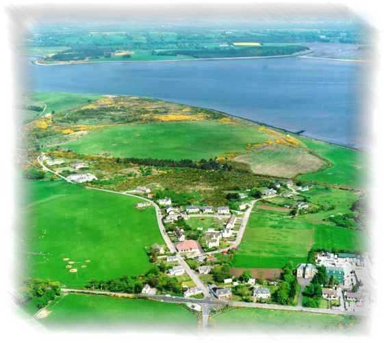
The village of Edderton is situated some 5 miles north of Tain on the A836 road to Bonar Bridge, on what is now known as the Struie by-pass. The abbey, now at Fearn, was first built here in Edderton west of the village, somewhere about the year 1225 where it remained for about 20 years. We also have a 'standing stone' "The Clach Biorach" which was used to observe the setting sun and moon throughout the year. The circle of stones, originally ten in number but now reduced to five was used to view the sun and moon by alignment with the standing stone. This all took place some 3500 years ago. The stone circle is known as the Carrieblair stone circle which is a reminder of the battle of Carrieblair several centuries ago. The leader of the opposing army is said to be buried under the standing stone, or due to the length of time that the stone has been there, perhaps buried at the foot of the stone.
. We don't have a shop anymore and shopping is collected, usually by car and sometimes by bus, from shops in Tain or other of the main towns i.e. Invergordon and Alness. Some people even go as far as Dingwall and Inverness. We do however have a mobile library and a similar service dealing in video tapes.
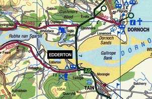
Map Of Edderton - Long 4 10.25W - Lat. 57 50.15N
We are a fairly compact little village with one Hotel, a sub-post office and the village hall.
There is Balblair Distillery for the whisky drinkers, and an excellent malt in my opinion. It is unfortunately only open to visitors by appointment. Our distillery was built in 1790 and came a close second place to the Strathisla Distillery built in 1786 near Keith in Banffshire and where Chivas Regal whisky is made.
There is also a Photographic studio who created the map shown above (DGS Photographic Studio), and an old folks home ready waiting for me and the wife. What a life <grin>.
As I said, we used to have a village shop but like many other villages in the North of Scotland, these are no longer viable propositions, and the one in this village closed.
The same is to be found in respect to petrol stations. I caution you now, if it is late in the day. The nearest OPEN petrol station, at night, is 16 miles away !! And don't talk to me about the price of fuel !!!
EDDERTON EAST CHURCH (The Old Church)
This church, graveyard and car park have been a place of worship and a centre for religion since early times. The present church was built about 1745 on the site of a pre-Reformation church, the remains of which still stand at the east end of the building.
Long before that, the Picts may have worshipped here and there is a Pictish Symbol Stone, dating from the eighth century standing inside the graveyard a few yards from the gate, amongst the gravestones. There is a Celtic Cross on the west side and a Roman Cross on the east side of the stone, although it is recently suggested that this might be a Jerusalem cross and the horse and rider may have been one of the army which went there to fight the Saracens.
It is possible that Irish monks, St Ninian's or St Columba's, probably the former, (see Fearn Abbey on the next page) came to this spot to preach the Gospel and convert the Picts to Christianity. These monks would also have taught the alphabet to the Picts using the Gaelic names of trees to express the sound of the letters. There are, or will be in the immediate future, identification name plates on each of the six tree species planted
To remind all of the heritage of this site, trees have planted around the churchyard and car park to illustrate this "Gaelic Alphabet of Tree Names". The trees were planted in 1992 and spell out the name 'EADAR DUN'
The well-being of the church building is secure in the hands of the Edderton Old Church Preservation Trust. An archaeological dig of the enclosure at the East end of the church will reveal the foundations of the pre-Reformation church, and that might in turn reveal another pictish stone or other artefacts similar to the finds at Portmahomack.
MEIKLE FERRY (No ferry now)
In the summer of 1809 a ferry so overloaded with passengers travelling from the Sutherland side of the Kyle, was swamped by waves when the wind fell and 99 people were drowned including Sheriff McCulloch of Dornoch who had urged the ferry men to leave some of the passengers behind. People were reluctant to use the ferry after this and travelled the long way around via the new iron bridge at Bonar built by Telford. As a matter of interest, there were plans in hand to build a bridge at the Meikle Ferry and such a bridge was designed by Robert Stevenson somewhere about 1830. Stevenson was responsible for building the Bell Rock Light House as stated in the Tarbat Ness Light page. The bridge was never built according to his plan, but a similar bridge of modern day materials was built in 199?? which cut out, apart from tourists, the road through Edderton, Ardgay and Bonar bridge.
Last update: 30th July, 2000
![]()
![]()
![]()