Odiham - from the Old English Wudighamm or Wudiham, meaning wooded settlement.
Odiham has been a part of the English countryside since at least the Bronze Age. King Harold held Odiham, before the Norman invasion, and the town continued as a royal manor until 1603. Despite it's idyllic setting, Odiham has been an important place through the centuries and has suffered the odd turbulent incident.
In 1216, the castle was famously besieged by the French for 15 days, until 9th July, when the defending "army" of 13 were granted safe passage - a number the French were a little surprised at!
In 1523, the king, Henry VIII, was preparing to invade France, he asked Odiham to muster 169 archers. Today, that legacy is remembered in such names as Butts End, Butts Cottages and Archery Fields. For several hundred years, the Law required that every able-bodied man practiced with the longbow.
And during May 1644, there was a battle between the Royalists and the Parliamentarians, at North Warnborough, which cost the lives of many Royalists and 150 were taken prisoner.
Much of Odiham has names associated with it's history - street names, house names and place names. Places such as Chamberlain Gardens, where the tennis courts, children's play park and the bowling green are, named after Prime Minister Neville Chamberlain's two sisters, Misses Hilda and Ida. These two ladies gave several gifts to the village, including the land listed above, as well as land for housing. Their house, Bury House, was a Ladies Boarding School in the mid 19th century.
Gurney Court, named after Sir Richard Gurney, was built with land left to the town in 1638. The land was Hammersmith Broadway, and the value of this land meant that the almshouses that bear his name were built and opened in 1969.
It is through these names that we remember events and people, and it affords us an insight into what has been given to us.
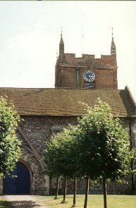
Looking more closely at the village and it's origins, it can be assumed that the original site is The Bury. The word itself comes from Bearh, meaning "hill". It is likely that this area was, as was typical of the time, a fortified hill. As Christianity spread in the early 300 - 400's AD, churches tended to be built on already-established places of worship, and while All Saints Church is not especially old, it is safe to say that there has been a church there for a long time, as there is mention of two churches in Odiham in Domesday Book. The base of All Saints tower dates from the 14th century and parts of the building are over 900 years old. The six bell peal dates from 1614 and the prayer-bell from 1588.
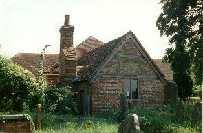
At the edge of the Churchyard, to the south, is one of five Pest Houses remaining in Great Britain. It was restored in 1981 by the Odiham Society and now houses a heritage centre, open at weekends and Bank Holidays. However, when it was built, in the early 1600's, it's purpose was rather more stark. Europe, at that time, was beset with the plague. Pest Houses were built for travellers, pilgrims and local people suffering with the plague and other epidemic diseases, and the building saw use until the beginning of the 19th century.
Beyond the Pest House, is the Odiham Cottage Hospital and a series of Almshouses. These are still in use today,thanks to the support of the village and OCHRE, although the hospital has undergone a Ł100,000 restoration. Next to the Bury, itself, are the stocks and pillory, perhaps, fortunately, not used today! After legislation in 1376, it was required that every town and village had stocks, as a deterrent for wrong-doers. While most towns have disposed of theirs, Odiham has retained theirs as a museum piece. Just next door is the Bridewell. Built in 1743, as a "House of Correction", it became a Police Station until 1972. It now houses a Police Post, the Library, a Learning Centre and a Computer Centre. Also in the Bury is Mayhill Junior School. There has been a school here since Robert May gave a bequest of Ł600 for the education of 20 boys of the town, in 1754. The original school no longer stands, but some the current school dates from 1876. Robert May, himself, is buried just outside the door of All Saints Church.
A visitor to Odiham might be surprised at the number of Oast Houses dotted around the town. They have all been converted to homes and offices, now, but in the past they supported the local farms which grew hops and Odiham Brewery, now a dentist's.
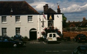
The town has lost some of it's pubs, now, but there are still one or two left, notably, The Bell, an interesting public house. There is a recess in the chimney where, it is reputed, people used to hide. The pub is worth a visit, just to sample the old-world charm of an untainted village pub (nice beer too!).
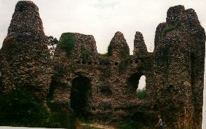
While it is commonly referred to as "King John's Castle", that which still stands is more probably the remains of the castle built by John's son, King Henry III, between 1216 and 1225. It is likely that the previous castle was irreparably damaged by the French in 1216.
The new castle was given by to his sister, Eleanor, in 1236, who married Simon de Montfort not long afterwards. De Montfort, the Earl of Leicester, added a few improvements of his own.
The castle fell into disuse in th 1400's and a complete picture of what the castle may have looked like is not available today. However, it was the only octagonal keep in Britain and it's walls were 10 feet thick. It was surrounded by two moats, the outer of which was up to 40 feet wide and crossed by a wooden bridge.
Hantsweb, links to the Hampshire Website and links throughout the county.
Originals Jewellery, beautiful handmade jewellery, Odiham High Street.
Harpers Computers, telecottage and hardware, The Bury.
La Foret, Bistro, Odiham High Street.