| IMAGES OF NORTH
LINCOLNSHIRE Sorry For Any Delay ! Unless you have a fast connection to the internet this page will take a few seconds to load. This is a selection of miscellaneous images from around North Lincolnshire. Click on the small image to see the larger version. Please read our copyright notice |
| Brigsley | |
| Church Lane, Brigsley. A small picturesque village situated 6 miles from Grimsby on the road towards Binbrook and Market Rasen (B1203). | |
| (JPEG 31k) | |
| Brigsley |  |
| Church Lane, Brigsley. A small picturesque village situated 6 miles from Grimsby on the road towards Binbrook and Market Rasen (B1203). | |
| (JPEG 27k) | |
| Brigsley | 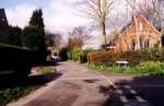 |
| Waithe Lane, Brigsley. A small picturesque village situated 6 miles from Grimsby on the road towards Binbrook and Market Rasen (B1203). | |
| (JPEG 27k) | |
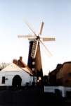
| Waltham | 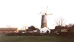 |
| Windmill (restored).This popular attraction is now under the control of the Waltham Windmill Preservation Society. | |
| (JPEG 11k) | |
| Waltham | 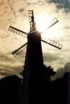 |
| Windmill (restored). The windmill now operates occasionally at certain weekends and public holidays during the summer months. | |
| (JPEG 14k) | |
| Waltham | 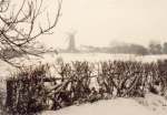 |
| Windmill, Photograph taken
circa 1985. Courtesy of Dave Enefer, Waltham |
|
| (JPEG 23k) | |
| Louth | 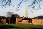 |
| The spire of St James Church, Louth is visible for miles around and is the highest Parish Church Spire in England at 295 feet (built between 1501 and 1515). | |
| (JPEG 25k) | |
| Louth | 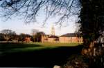 |
| Historic market town 12 miles south of Holton le Clay. | |
| (JPEG 28k) | |
| Louth | 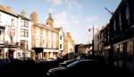 |
| Market Place | |
| (JPEG 20k) | |
| Louth | 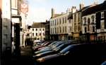 |
| Market Place | |
| (JPEG 23k) | |
| Conisholme | 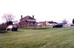 |
| Appleby's Ice Cream shop at Conisholme on the A1031 between Grimsby and Mablethorpe. Popular with week-end motorists and cyclists. | |
| (JPEG18k) | |
| Cadwell Park | 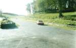 |
| Motor Racing circuit, near Louth, Lincolnshire. One of the most demanding racing circuits in the country, set in a rural location within the lincolnshire wolds. | |
| (JPEG 19k) | |
| Cadwell Park | 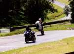 |
| Motor Racing circuit, near Louth, Lincolnshire. | |
| (JPEG 19k) | |
| Cadwell Park |  |
| Motor Racing circuit, near Louth, Lincolnshire. | |
| (JPEG 25k) | |
| Barton-on-Humber | 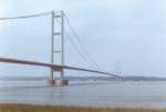 |
| (JPEG 10k) | |
| Barton-on-Humber | 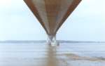 |
| The Humber Bridge from the south bank at Barton-upon-Humber. | |
| (JPEG 10k) | |
| River Bain | 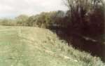 |
| Pictured at Kirkby-on-Bain near Horncastle, Lincolnshire. A popular venue for "small river" roach and chub fishing. | |
| (JPEG 20k) | |
| River Bain | 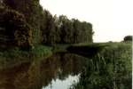 |
| Pictured at Kirkby-on-Bain near Horncastle, Lincolnshire. A popular venue for "small river" roach and chub fishing. | |
| (JPEG 20k) | |
| Louth Navigation Canal | 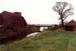 |
| At "Thoresby Bridge", near North Thoresby, Lincolnshire (disused grain store pictured) | |
| (JPEG 14k) | |
| Louth Navigation Canal | 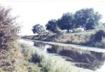 |
| Near Tetney Lock, Lincolnshire | |
| (JPEG 25k) | |
| North Willingham | 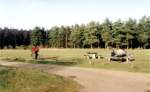 |
| Willingham Woods forest and picnic area, near Market Rasen, Lincolnshire. Forestry commission land with forest walks, a small lake, playing field and picnic area. Popular for Sunday afternoon walks especially in the summer months (website). | |
| (JPEG 23k) | |
| North Willingham | 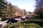 |
| Willingham Woods forest and picnic area, near Market Rasen, Lincolnshire. Forestry commission land with forest walks, a small lake, playing field and picnic area.Very popular 'pit stop' for bikers at week-ends (website). | |
| (JPEG 31k) | |
| The Lincolnshire Wolds |  |
| Near the village of Stainton-le-Vale. | |
| (JPEG 17k) | |
| The Lincolnshire Wolds | 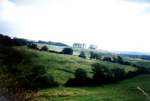 |
| Between Walesby and Tealby close to the Viking Way footpath which traverses the Lincolnshire Wolds. | |
| (JPEG 17k) | |
| Back to Images | Home Page |