
Weather Outlook for the next few days
Portmahomack known colloquially, or should that be locally, as "The Port" is a (former) fishing village, and is situated on the north side of the Tarbat Ness peninsular and about 10 miles east of Tain. The harbour was created by Thomas Telford early in the 19th century.
In days gone by, the harbour would have been packed with ships like this returning to harbour or about to put to sea. The harbour is now mainly used by pleasure craft
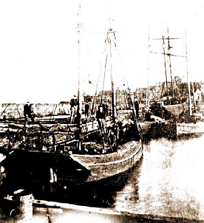
It would have been nice to be able to identify the boats in the harbour displayed here, and the people who sailed in them, and go from there to their families but as time passes by, the old merge in with the new and the new then become the important. Some of us may regret that our family tree is not there for posterity.
The harbour obviously remains but the fishing boats are long gone. Any left overs, so to speak, are all part of the every decreasing circle of fishing boats, reduced day by day by the de-commissioning policies carried out by the government - to preserve stocks of fish. The fish were never in any real danger until the advent of the factory ships which took everything from an area and left it almost barren.
For a panoramic view, . the hill of Knockshorty, rising to a height of 150ft + above the village, offers the best vantage point.
From here can be seen :- to the north Morven (2313 metres) and Ben Klibreck :-to the north west Ben More Assynt :- to the south east Ben Rinnes :- to the south the Cairngorms and to the south west - Ben Wyvis
On a clear night a necklace of lights can be traced along the northern shore of the Dornoch and Moray Firths, from Tain, Dornoch, Golspie, Brora and Helmsdale and, I am assured, the lighthouse on Noss Head just north of Wick.
If you can't see that far, like me, there are the white walls of Dunrobin Castle at Golspie,

and The Duke of Sutherland's Monument (commonly known as "The Mannie") on top of Beinn a' Bhragaid just across the water , so to speak, on the Sutherland coast!! And, of course, it is better to see these two landmarks in daylight.

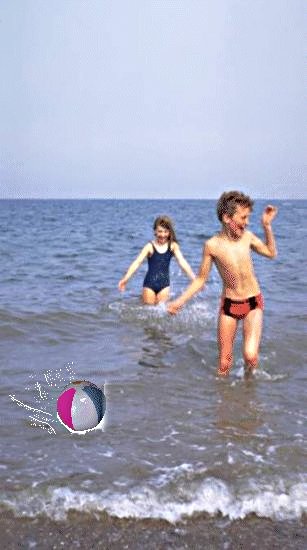
On a clear day, you can see across the water to Inver, just along the same coast, with its outstanding beach. They have a very nice beach at Portmahomack too, from where all the modern go-faster water sports seem to flourish.
Beyond Inver you can see the beach at Tain with the bright red bombing practice range. That causes a great amount of arguments and complaints to the authorities but, personally , I love to hear the whine of the jet engines. Brings it all back to me <grin>. After years of listening to the Vulcan and Valiant bombers doing their "circuits and bumps" ( take off and landing practice), I still find the sound of raw power to be wonderful. Still, that is only my opinion.
We have been treated over the years, with an annual visit by a Shackleton which flies overhead at low altitude, and at a very slow speed, so much so that you can see the rivets in her skin. A grand old lady.
And if you look further to the west, past the radio mast on the hill at the Struie, just above Edderton, you can see right up into the neck of the Kyle and if you see the rain squalls coming from there, you have about twenty minutes to seek shelter or get your "wet suit" on.
To the north, the entrance to Loch Fleet can been seen, between Embo and Golspie. Loch Fleet is a birdwatchers paradise and you can also see the salmon milling in the water below the road bridge as they wait for the sluice gates to be opened so that they can continue their trip to the spawning grounds. Children stand fascinated when the big fish appear to take turns jumping out of the water.
And the Tarbat Ness lighthouse just to the east of you. Pop along there and see it. The next arrow does it !
Portmahomack Old Parish Church is to be preserved and refurbished, before being transformed into an archaeological Discovery Centre, The Tarbat Historic Trust, based on the ancient settlement which Professor Carver (Archaeological director) and his team have already proved to have existed on the site. Details of this site, and all other sites in the Highland Region of Scotland can be obtained from their site.
The site has just been awarded generous funding in the form of an annual scholarship granted by the Meftah Scholarship Foundation of Naples, Florida through St Andrews Presbyterian College in North Carolina, because of its many affiliations with Scottish Organisations in America The scholarship will enable an American student to train for six weeks each summer, for the next three or four years, with the team of archaeologists from the University of York working under the direction of Professor Carver on the site adjoining the Tarbat Old Church at Portmahomack
Work has already begun on the restoration of the Old Parish Church, but it seems to be taking longer than was expected. I visited there in April this year and I saw that the exhibition centre is to open in mid -July. It is quite adequately sign posted. I had been disappointed with the apparent lack of progress but as someone said to me recently, if history took so long to make, then you can not expect the present to make history for many years.
The Discovery Centre will provide an exciting all-weather attraction for visitors of all ages from a very wide area, as well as being used by the local community for recreation, cultural and educational purposes,
The Tarbat Discovery Centre is situated on the road leading to the school when arriving in the village from the direction of Tain. It should not be confused with the Free Church standing on the left and adjacent to the foreshore
![]()
Last Update: 1st February, 2000.
![]()
![]()
![]()