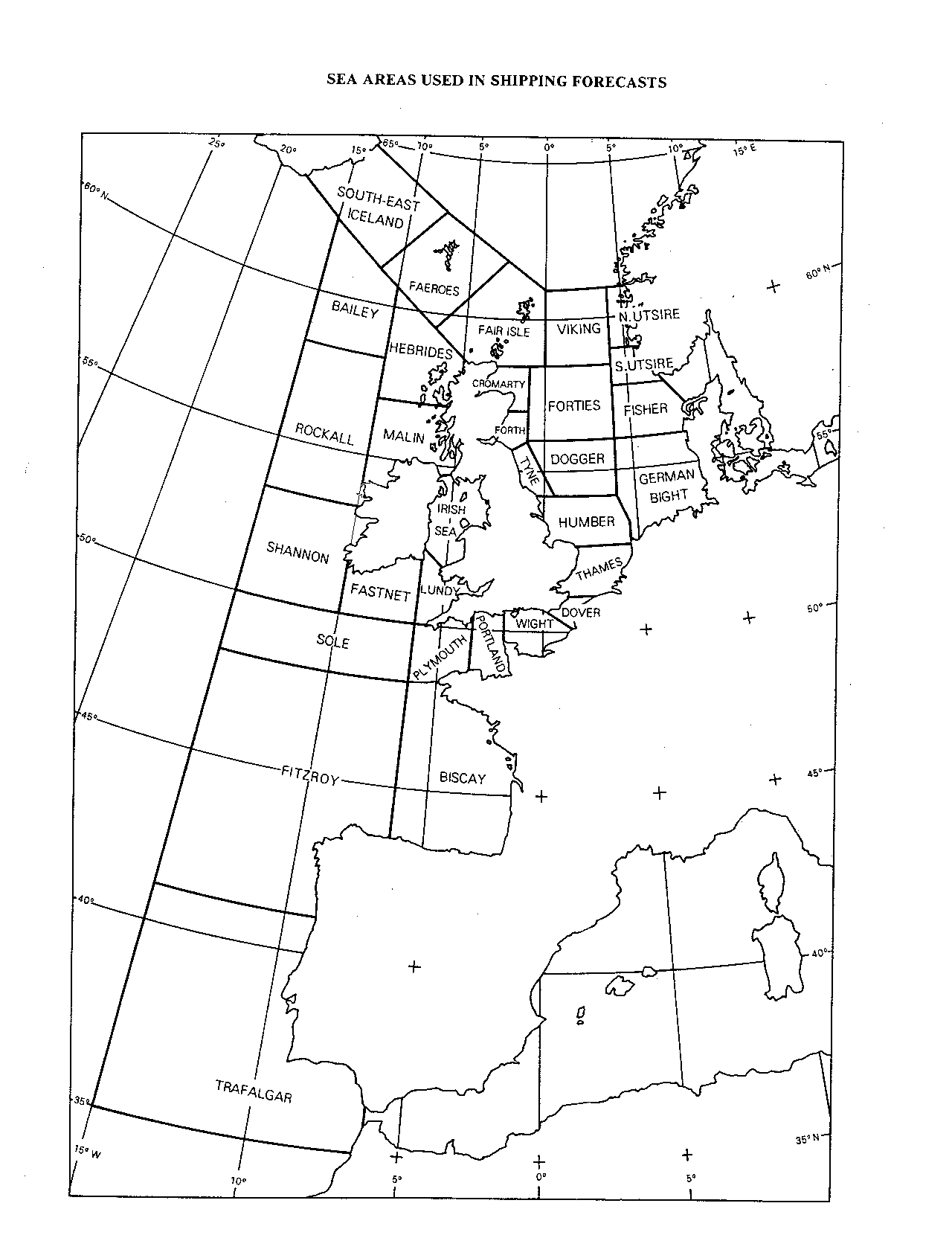
VIKING
61°00'N 00°00'
61°00'N 04°00'E
58°30'N 04°00'E
58°30'N 00°00'
|
NORTH
UTSIRE
61°00'N 04°00'E
61°00'N 05°00'E
59°00'N 05°35'E
59°00'N 04°00'E
|
SOUTH
UTSIRE
59°00'N 04°00'E
59°00'N 05°35'E
58°00'N 07°05'E
57°45'N 07°30'E
57°45'N 04°00'E
|
FORTIES
58°30'N 01°00'W
58°30'N 04°00'E
56°00'N 04°00'E
56°00'N 01°00'W
|
FORTH
55°40'N 01°50'W
56°00'N 01°00'W
57°00'N 01°00'W
57°00'N 02°10'W
|
CROMARTY
57°00'N 02°10'W
57°00'N 01°00'W
58°30'N 01°00'W
58°30'N 03°00'W
|
TYNE
54°15'N 00°20'W
54°15'N 00°45'E
56°00'N 01°00'W
55°40'N 01°50'W
|
DOGGER
56°00'N 01°00'W
54°15'N 00°45'E
54°15'N 04°00'E
56°00'N 04°00'E
|
FISHER
57°45'N 04°00'E
56°00'N 04°00'E
56°00'N 08°10'E
57°05'N 08°35'E
57°45'N 07°30'E
|
GERMAN
BIGHT
56°00'N 08°10'E
56°00'N 04°00'E
54°15'N 04°00'E
53°35'N 04°40'E
52°45'N 04°40'E
|
HUMBER
52°45'N 01°40'E
52°45'N 04°40'E
53°35'N 04°40'E
54°15'N 04°00'E
54°15'N 00°20'W
|
THAMES
51°15'N 01°25'E
51°15'N 02°55'E
52°45'N 04°40'E
52°45'N 01°40'E
|
DOVER
50°45'N 00°15'E
50°15'N 01°30'E
51°15'N 02°55'E
51°15'N 01°25'E
|
WIGHT
50°35'N 01°55'W
49°45'N 01°55'W
50°15'N 01°30'E
50°45'N 00°15'E
|
PORTLAND
50°25'N 03°30'W
48°50'N 03°30'W
49°45'N 01°55'W
50°35'N 01°55'W
|
PLYMOUTH
50°05'N 05°45'W
50°00'N 06°15'W
48°27'N 06°15'W
48°27'N 04°45'W
48°50'N 03°30'W
50°25'N 03°30'W |
BISCAY
48°27'N 06°15'W
43°35'N 06°15'W
48°27'N 04°45'W
|
TRAFALGAR
35°00'N 15°00'W
35°00'N 06°15'W
41°00'N 08°40'W
41°00'N 15°00'W
|
FITZROY
48°27'N 15°00'W
41°00'N 15°00'W
41°00'N 08°40'W
43°35'N 06°15'W
48°27'N 06°15'W
|
SOLE
50°00'N 06°15'W
50°00'N 15°00'W
48°27'N 15°00'W
48°27'N 06°15'W
|
LUNDY
52°30'N 06°15'W
50°00'N 06°15'W
50°05'N 05°45'W
52°00'N 05°05'W
|
FASTNET
51°35'N 10°00'W
50°00'N 10°00'W
50°00'N 06°15'W
52°30'N 06°15'W
|
IRISH
SEA
54°50'N 05°05'W
54°45'N 05°45'W
52°30'N 06°15'W
52°00'N 05°05'W
|
SHANNON
53°30'N 15°00'W
50°00'N 15°00'W
50°00'N 10°00'W
51°35'N 10°00'W
53°30'N 10°05'W
|
ROCKALL
58°00'N 10°00'W
58°00'N 15°00'W
53°30'N 15°00'W
53°30'N 10°05'W
54°20'N 10°00'W |
MALIN
57°00'N 05°50'W
57°00'N 10°00'W
54°20'N 10°00'W
54°45'N 05°45'W
54°50'N 05°05'W |
HEBRIDES
60°35'N 10°00'W
57°00'N 10°00'W
57°00'N 05°50'W
58°40'N 05°00'W |
BAILEY
62°25'N 15°00'W
58°00'N 15°00'W
58°00'N 10°00'W
60°35'N 10°00'W |
FAEROES
63°20'N 07°30'W 61°10'N 11°30'W 59°30'N
07°15'W 61°50'N 02°30'W |
FAIR
ISLE
61°50'N 02°30'W
59°30'N 07°15'W
58°40'N 05°00'W
58°30'N 03°00'W
58°30'N 00°00'
61°00'N 00°00' |
SOUTHEAST
ICELAND
63°35'N 18°00'W
61°10'N 11°30'W
63°20'N 07°30'W
65°00'N 13°35'W |
|