Forecasts for the High Seas world-wide are now available on the Internet via
the WMO JCOMM site. However, with internet
access at sea still an expensive option, the texts can be downloaded via the
free facilities of the Météo-France Navimail system*. The Navimail
system provides forecasts up to 5 days ahead for any part of the world. The
system is Windows based and can be used through any telecom standard that supports
e-mail (INMARSAT - A, B, C or Mini-M, GSM, telephone etc.). This method allows
for the download of very small files (of the order of 2kB) hence time spent
on the Internet is minimal. The links below can be accessed free of charge,
but a credit account with Météo France is needed to use those
parts of the Navimail system which are not free.
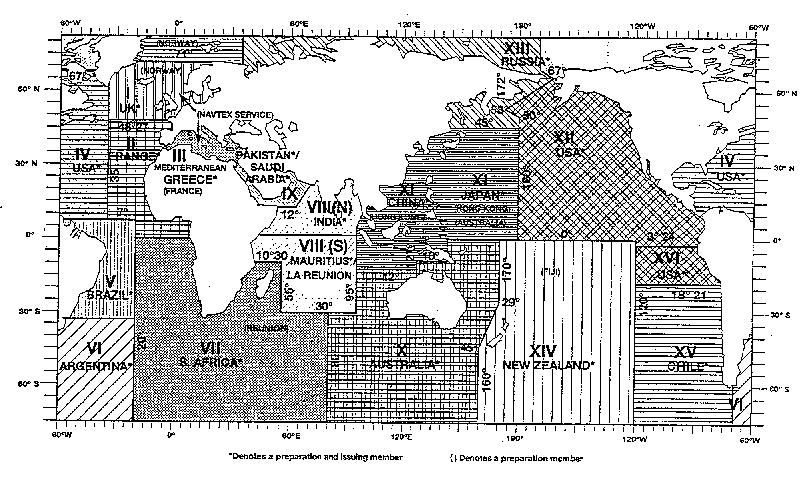
The table below provides the links to access the forecasts provided for the
individual Metareas (see details of co-ordinates of the
Metareas and the map of the Metareas for more
information re the boundaries of Metareas). Oncea link has been used just save
the appropriate link(s) in your Bookmarks or Favourites for future quick downloads
of the forecasts. But do use the Refresh or Restore Button
to ensure that you are not accessing an out-of-date forecast in your cache.
When using the Internet for accessing safety information the responsibility
is on the user to ensure that the information downloaded
is the latest issue.
Also note the Caution in the box below and which appears at the head of each text received via the Navimail facility.
*More details re the Navimail Service can be found on the
Météo-France site and
also on Frank Singleton's site
for sailors.
|
NAVIMAIL is not part of the Maritime Safety Information's operational data stream and should never be relied upon as the only means to obtain the latest forecast and warning information. Access to the service may be interrupted or delayed from time to time, and updates may also experience occasional gaps. Please refer to GMDSS OFFICIAL sources, Inmarsat SafetyNET or international NAVTEX services, for more complete information |
| Metarea I (High Seas forecast) | North-east Atlantic Ocean – High Seas forecast East of 35°W |
| Metarea I (Offshore Bulletin) | Shipping Forecast includes North Sea, Irish Sea, English Channel, Bay of Biscay, waters out to 15°W north of 35°N and to south-east of Iceland |
| Metarea 2 | Eastern Part of North Atlantic Ocean south of 48°27'N |
| Metarea 3 (West) | Western areas of the Mediterranean Sea (west of Italy and Sicilia) |
| Metarea 3 (East) | Eastern areas of the Mediterranean Sea (east of Italy and Sicilia) |
| Metarea 4 | North Atlantic Ocean west of 35°W and north of 7°N |
| Metarea 5 | Northrn Part of South Atlantic Ocean west of 20°W |
| Metarea 6 (North) | South Atlantic Ocean south of 20°S to 60S, west of 20°W |
| Metarea 6 (South) | South Atlantic Ocean South of 60°S, west of 20°W |
| Metarea 7 | SE Atlantic Ocean east of 20°W + extreme SW of Indian Ocean |
| Metarea 8 (North) | North Indian Ocean |
| Metarea 8 (South) | Southwestern part of Indian Ocean |
| Metarea 9 | Red Sea, Gulf of Aden, Arabian Sea, Persian Gulf |
| Metarea 10 (NE Australia/Pacific) | Northeast of Australia (Pacific Ocean) |
| Metarea 10 (North of Australia) | North of Australia |
| Metarea 10 (South-east) Indian Ocean | Southeastern part of Indian Ocean |
| Metarea 10 (SE of Australia/Pacific) | Southeast of Australia (Pacific ocean) |
| Metarea 11 (West part of N Pacific) | Western part of the North Pacific Ocean (Responsibility of China) |
| Metarea 11 (West part of N Pacific) | Western part of the North Pacific Ocean (Responsibility of Japan) |
| Metarea 11 (West part of S Pacific) | West Pacific Ocean, south Equator (Responsibility of Australia) |
| Metarea 12 (E part of N Pacific) | Eastern part of the North Pacific Ocean (E of 120°W) |
| Metarea 13 (NW Pacific and Arctic) | Northwest of North Pacific and part of Arctic waters |
| Arctic Ocean | From SW corner 67°N, 44°E to NE corner 80°N, 165°W |
| Metarea 14 (South of 25°S) | South Pacific south of 25°S bounded by areas X and XV |
| Metarea 14 (North of 25°N | South Pacific north of 25°S bounded by areas X, XII and XV |
| Metarea 15 | Southeast Pacific to west of Chile– Link currently to JCOMM page |
| Metarea 16 (SE Pacific 18S-3S) | Southeast Pacific easst of 120°W between approx 18°S and 3°S |