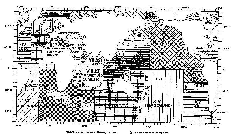
The table below is reproduced from that published in the WMO Manual on Marine Meteorological Services,
WMO-No.558.
WMO publications may now be ordered online -
go to the WMO site for more details - click on Publications.
| Metarea | Details of boundaries |
|---|---|
| The North Atlantic Ocean east of 35°W, from 48°27'N to 71°N including the North Sea and Baltic Sea sub-area. | |
| Atlantic waters east of 35°W, from 7°N to 48°27'N, and east of 20°W from 7°N to 6°S. | |
| The Mediterranean and Black Seas, east of the Straits of Gibraltar. | |
| The western part of the North Atlantic Ocean eastwards of the North American coast to 35°W, from 7°N to 67°N, including the Gulf of Mexico and Caribbean Sea. | |
| Atlantic waters west of 20°W from 35°50'S to 7°N, narrowing in the coastal strips at the extremities to the Uruguay/Brazil frontier in 33°45'S and the French Guyane/Brazil frontier in 43°00'N. | |
| The South Atlantic and Southern Oceans south of 35°50'S, from 20°W to the longitude of Cape Horn, 67°16'W | |
| The South Atlantic and Southern Oceans south of 6°S from 20°W to the coast of Africa, thence south to the Cape of Good Hope; the South Indian and Southern Oceans south of 10°30'S from the Cape to 55°E, thence south of 30°S to 80°E. | |
| The area of the Indian Ocean enclosed by lines from the Indo-Pakistan frontier in 23°45'N 68°E to 12°N 63°E, thence to Cape Gardafui; the east African coast south to the equator, thence to 95°E, to 6°N, thence NE'wards to the Myanmar/Thailand frontier in 10°N 98°30'E. | |
| The east African coast from the equator south to 10°30'S, thence to 55°E, to 30°S, to 95°E, to the equator, to the east African coast. | |
| The Red Sea, Gulf of Aden, Arabian Sea and Persian Gulf, north of Area VIII. | |
| The South Indian and Southern Oceans east of 80°E and south of 30°S to 95°E, to 12°S, to 127°E; thence the Timor Sea, South Pacific and Southern Oceans south of 10°S to 141°E to the equator, to 170°E, to 29°S, thence SW'wards to 45°S in 160°E, then the 160°E meridian. | |
| The Indian Ocean, China Sea and North Pacific Ocean northward of Area X and on the equator to longitude 180°, eastward of Area VIII and the Asian continent to the North Korea/Russian Federation frontier in 42°30'N 130°E, thence to 135°E, NE'wards to 45°N 138°E, to 45°N 180°. | |
| The eastern part of the Pacific Ocean, west of the North and South American coast and east of 120°W, from 3°24'S to the equator, thence to 180°, to 50°N thence NW'wards to 53°N 172°E, NE'wards following the marine frontier between United States and Russian Federation waters to 67°N. | |
| Sea areas enclosed north of Area XI and west of Area XII; also all Arctic waters from 170°W westwards to 20°E. | |
| The South Pacific and Southern Oceans south of the equator, bounded by Area X to the west, Area XII to the north and Area XV to the east. | |
| The South Pacific and Southern Oceans south of 18°21'S following the coast of Chile to the longitude of Cape Horn in 67°16'W, and 120°W | |
| The South Pacific Ocean between 18°21'S and 3°24'S bounded by the coast of Peru and 120°W | |