Topics:
WEATHER INFORMATION VIA NAVTEX
What exactly is NAVTEX?
NAVTEX is a system for sending NAVigational TEXt messages via radio to vessels at sea. The receiver is a radio receiver and a direct-printing system for the reception of the safety messages. Messages include gale warnings, sea area weather forecasts, navigational warnings and other safety information. All vessels over a certain size have to carry NAVTEX equipment within the Global Maritime Distress and Safety System (GMDSS) Regulations. There is the International System which uses the frequency of 518 kHz world-wide and the National System which uses a frequency of 490 kHz. Safety messages on 518 kHz have to be in the English language world-wide but broadcasts on the 490 kHz frequency can be in the local language. More details
What are the advantages of NAVTEX?
The recipient of Safety information does not have to tune the receiver or be physically present at fixed times since all transmissions world-wide are on the same frequency (518 kHz) and must be in English. Each station has a 10-minute transmission slot every four hours. The equipment can be programmed to receive broadcasts from particular stations, or from a group of stations so that information relative to the area of interest is received.
Are the UK shipping forecasts available via NAVTEX?
The three UK NAVTEX stations (Cullercoats on the North-east
coast of England, Niton on the Isle of Wight, and Portpatrick
in the South-west of Scotland) include the Shipping Forecasts twice a
day for their areas of responsibility. Gale Warnings are broadcast on
receipt and repeated in the next scheduled broadcast slot.
An Extended Outlook highlighting expected hazards over a period of a
further three days beyond the forecast is also broadcast once a day by each
of the three UK NAVTEX stations. Full details are given in Marine Weather
Services, a booklet available from the Met Office.
Why are the shipping forecasts for the more eastern North Sea areas not available via UK NAVTEX stations?
All countries in Europe provide input to the International NAVTEX service. The sea areas in the eastern part of the North Sea are adequately covered in the Norwegian NAVTEX broadcasts. Any problems with the content of NAVTEX broadcasts should be addressed to the International NAVTEX Co-ordinator at the Hydrographic Office at Taunton.
Niton and Cullercoats are very difficult to receive in the southern part of the North Sea - can I get forecasts in English by any other means?
Yes. Forecasts for Dogger, German Bight, Humber, and Thames prepared by the KNMI are broadcast via the NAVTEX station Den Helder [P] in the Netherlands - slot times at 0230 and every four hours. The bulletins, in English, contain a 12-hour forecast and a 12-hour outlook and are updated twice a day. Gale warnings are also included in the above broadcast for the above areas and also for the additional areas Dover, Fisher, Forties and Viking.
What are the changes to the Niton NAVTEX service on 518kHz with effect
from 12:00UTC on 17th Sept?
The B1 character of the broadcast (that is the character that is programmed
into the receiver to receive transmissions from specific NAVTEX stations) is
being changed from 'S' to 'E'. This change will mean that the Niton broadcasts
will be during different slot times to those in the past, namely at 0040UTC,
0440UTC and every four hours instead of at 0300UTC, 0700UTC and every four hours.
What happens if I don't reprogram the B1 character for the Niton broadcast?
You will get no information at all!
When can I get the forecasts from Niton when the change is made?
The routine weather forecast bulletins will be at 0840 and 2040UTC and the Extended
Outlook bulletin will be transmitted in the 0040UTC slot time. Gale warnings
are broadcast when received and repeated in the next scheduled ten-minute slot.
Having difficulties in receiving Portpatrick and Niton NAVTEX broadcasts when sailing to the south and west of Ireland?
The sea areas for the more western areas in the Shipping Forecast issued by the Met Office are now included in the NAVTEX broadcasts disseminated by Malin Head and Valentia courtesy of the Irish Coastguard. The forecasts for the two eastern High Seas areas of the North Atlantic issued by the Met Office are also included in the NAVTEX transmissions from Malin Head and Valentia.
NATIONAL NAVTEX SERVICE
What is this National NAVTEX service on 490 kHz?
This frequency (490 kHz) has been allocated for copuntries to operate a National NAVTEX service. Many non-English speaking countries are using the National service to disseminate forecasts and warnings in their National Language. In the UK, the service is being used to provide information which cannot be included on the International channel due to time limitations. The relevant areas of the Inshore Waters forecast are broadcast by all three UK stations (details in the Marine Weather Services booklet).
Is the forecast for the Inshore Waters available via NAVTEX?
Yes. The Maritime and Coastguard Agency have commissioned a detailed Inshore Waters forecast from the Met Office for dissemination via the HM Coastguard broadcasts and also via the new National Navtex service on 490 kHz. Full details in the Marine Weather Services booklet.
What improvements have been made to the Inshore Waters forecast available
via NAVTEX and the Coastguard
Following feedback from the users of the 16-area Inshore Waters Forecast the
12-hour forecast period has been extended to a 24-hour period, plus an outlook
(same detail as the forecast) for a further 24 hours for each of the sixteen
areas. Following the detailed forecasts and outlooks for each area, a short
general outlook is given for a further three days highlighting any weather hazards
expected in the following three days..
I am having difficulties in receiving the service on 490 kHz - to whom do I seek advice?
If it is because your receiver is a one frequency receiver then you need to discuss the options available to convert your receiver into one that can receive on both channels. Maybe a simple switching device in the aerial lead in may be a solution, but you may wish to contact one of the manufacturers of NAVTEX equipment and then make a decision based on your particular needs and budget.
If, however, you have the facility to receive on both channels and have difficulty with the transmissions on 490 kHz then you should contact the Maritime and Coastguard Agency as they are responsible for the transmission of the broadcast.
Where can I get more information about NAVTEX?
A comprehensive discription of the NAVTEX service and details of the UK and
Irish stations can be accessed on this site. NAVTEX
pages
The Maritime and Coastguard Agency in Southampton have leaflets giving more details re the broadcasts, but for information on NAVTEX receivers and reception it is best to contact one of the manufacturers of NAVTEX equipment.
Who pays for this information provided via NAVTEX?
The Maritime and Coastguard Agency fund
the provision of safety information disseminated via NAVTEX and that includes
the weather forecasts and warnings which are supplied by the Met Office.
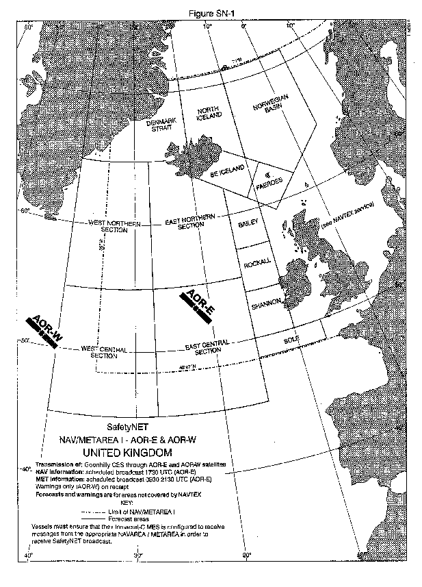
FORECASTS AND WARNINGS FOR THE HIGH SEAS
The Met Office provides a Storm Warning service and forecasts for the High Seas of the North Atlantic in Metarea I (east of 35°W and north of 48°27'N). The High Seas areas in the forecasts issued by the Met Office currently extend to 40°W and 45°N - these boundaries currently overlap the bouhdaries with Metarea II (responsibility of France) and with Metarea IV (responsibility of the USA).
Where can I get these Forecasts and Warnings for the High Seas?
The bulletins are broadcast via the Inmarsat satellite SafefyNET™ service at 0930 and 2130 UTC. Storm Warnings are broadcast as and when issued.
Since Portishead Radio closed I cannot receive the High Seas forecast, is there any other source?
The Irish Coastguard now include the East North and East Central areas in their NAVTEX transmissions. Detailsare the Marine Weather Services booklet available from the Met Office, or in the various publications of the Hydrographic Office such as the Admiralty List of Radio Signals.
Can I get the High Seas forecast by e-mail when at sea?
Yes - both the High Seas forecast and also the Shipping forecast can be obtained
by the FTPmail service via the US National Weather Service. The service is free
other than the cost of sending and receiving the e-mails at sea. To receive
the forecast one has to send a simple e-mail request (content must conform to
the standard format laid down), and normally within an hour the forecast requested
is sent to the address quoted (which can be an address other than that of the
sender). A summary of the procedures is given on this
site and for a full description of the service click
here for the relevant NWS page and scroll down to the section describing
FTP Mail, or you can go directly to the text.
You can also get the forecasts issued by National Met Services world-wide for
their areas of responsibility via NAVIMAIL. The bulletins are in pure text format
and hence not costly downloads. More information
re the NAVIMAIL service.
What are the areas mentioned in the High Seas forecasts?
The areas include the high sea areas West and East Central Sections, West and East Northern Sections, Denmark Strait, North Iceland and Norwegian Basin. Also included are several of the more western areas included in the main shipping forecast. Click here to view a copy of the revised boundaries that appeared in a recent Admiralty Notices to Mariners.
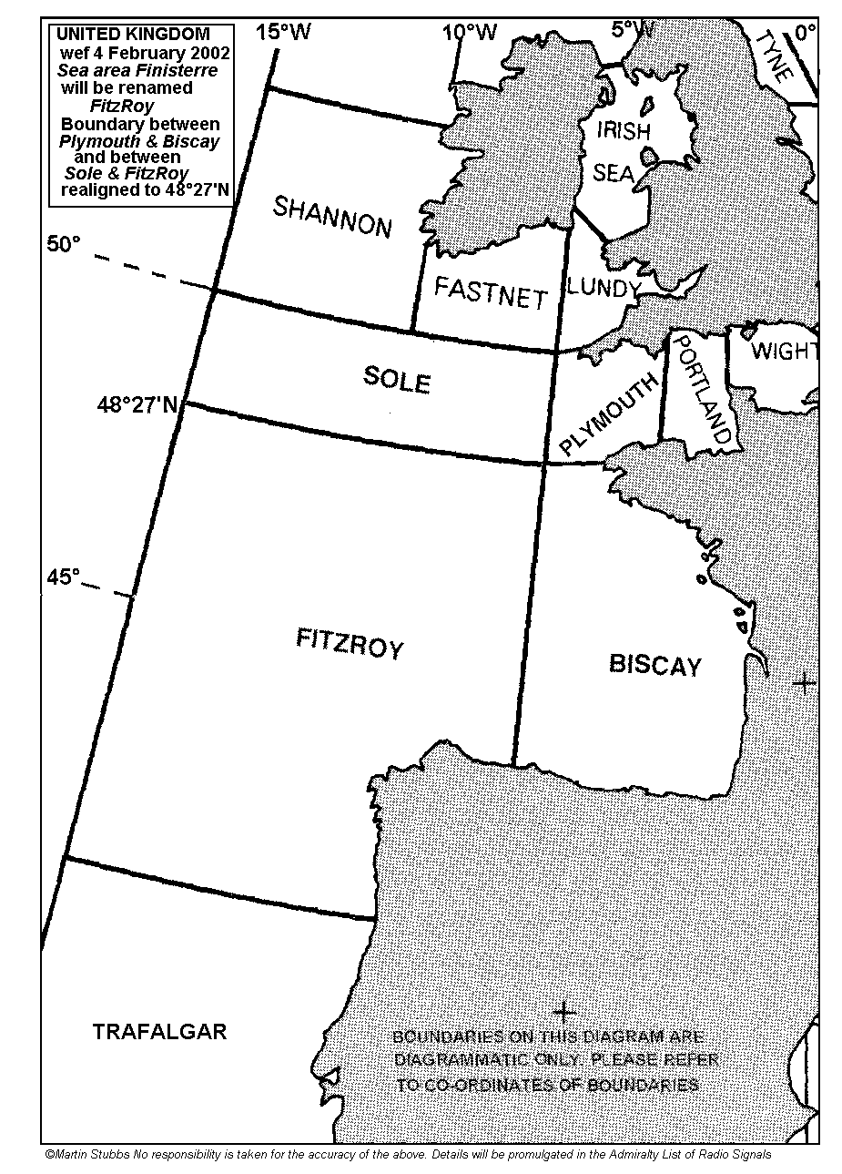
SEA AREA REVISION WEF 4th FEBRUARY 2002
On the 4th February 2002 the boundary between sea areas PLYMOUTH and BISCAY and between SOLE and FINISTERRE was realigned along latitude 48°27' North. At the same time the sea area FINISTERRE used by the United Kingdom was renamed FITZROY. The realignment of the boundaries meant that the boundary between Sole and Finisterre was moved 57 nautical miles northwards of its previous position, and the boundary between Plymouth and Biscay 57 nautical miles northwards in the west and three nautical miles southwards on the French coast.
Since 4th February 2002 France, Spain, Portugal and Morocco are all using a common set of sea areas. This revision has resulted in big changes from the areas in use by the four countries prior to the 4th February 2002.
Why were the boundaries of the sea areas changed?
The responsibility for the provision of warnings and forecasts for the seas and oceans of the world is divided between Nations and each designated Nation has a particular area of responsibility - these areas are known as Metareas. The UK is responsible for Metarea I and France for Metarea 2. The Ruling bodies responsible for the regulations governing the provision of these forecasts and warnings have laid down that sea areas should not overlap Metarea boundaries. Hence the realignment of the sea area boundaries to the Metarea I/II boundary at 48°27' North.
Why was the name Finisterre changed to FitzRoy?
Those countries providing forecast input for Metarea II (France, Portugal, Spain and Morocco) have agreed on a common set of areas within Metarea II (a similar exercise to that undertaken several years ago for those countries issuing forecasts for the North Sea). Spain has used a sea area Finisterre for many years and this area has been retained in the new co-ordinated set of areas for Metarea II. As this area has different co-ordinates to the area used by the UK (less than half the size of the area that the UK called Finisterre) the United KIngdom agreed to change the name of the area called Finisterre in the forecasts for shipping. Click here for a diagram showing the current revised boundaries of the areas in the South-west Approaches.
What are the changes to the sea areas that the French will be using?
The changes are extensive. Anybody expecting to be sailing in Metarea II is well advised to become familiar with the new areas.
Where can details be found regarding all these changes?
Click here for more details and charts showing the revised areas on this site.
The fully revised 2002 edition of the Marine Weather Services booklet
is available from the Met Office. This excellent free publication contains details
of the areas now used by the United Kingdom and also those used by France, Spain,
Portugal, and Morocco in their forecasts for shipping via NAVTEX and Inmarsat.
The booklet also contains full details of the various broadcasts of weather
information for shipping by the United Kingdom and the many other value added
services available from the Met Office. The booklet may be ordered online via
the leisure marine section of the Met
Office Web site. Details of the revised areas in Metarea II are are also
available on the marine (Mer) page on the Météo-France
web site.
The radio-facsimile broadcast supported by the Met Office ceased in April 2001.
Can I get any meteorological information while at sea via radio-fax broadcasts
There are two broadcasts, the Deutscher Wetterdienst broadcast and the Royal
Navy broadcast disseminated from the Fleet Weather and Oceanographic Centre
at Northwood. Although the Northwood broadcast is primarily for the Royal Navy
it now contains a wealth of charts for the marine community, the charts (for
the whole of the North Atlantic, Europe and the Mediterranean) are based on
the computer output from the Met Office and adjusted by the highly skilled forecasters
at Northwood.
How to obtain a schedule for the Northwood broadcast
The frequencies of the broadcast are included in the Marine Weather Services
brochure. The schedule is broadcast at 0236 and 1424UTC. In the coming months
two further frequencies may be added, but at any one time the broadcast will
be promulgated on just four frequencies.
Comments on the Northwood broadcast
Any comments should be directed to
Fleet Weather & Oceanographic Centre NCC, 00000
Northwood HQ,
NORTHWOOD, HA6 3HP
(Note that the Met Office has no control over this broadcast).
Why was the Bracknell broadcast stopped?
The broadcast was mainly for the dissemination of aviation products although
the broadcast did carry a set of charts for the marine community. Taking into
account that a dedicated radio-facsimile service for shipping in the waters
off North and west Europe and the eastern parts of the North Atlantic is disseminated
by the Deutscher Wetterdienst there was no justification to maintain the UK
facsimile broadcast solely for marine use in view of the very high costs involved.
What are Metareas?
Metareas are areas of the oceans and seas around the world corresponding to NAVAREAs. NAVAREAs are defined in the Safety of Life at Sea Regulations with specific countries having responsibilities for the issue of Navigational Warnings for the areas defined. The boundaries of the NAVAREAs are the same as for the Metareas, the latter being areas for the issue of meteorological warnings and forecasts.
Do I need to know anything about the boundaries of Metareas?
Not necessarily although it is useful to know the boundaries of the Metareas and the countries responsible for the issue of warnings and forecasts for the said area. For example, Metarea I is the responsibility of the United Kingdom Met Office and the Norwegian Met service. The Met Office provides the high seas forecasts for Metarea I and also forecasts for issue via NAVTEX and the HM Coastguard Service on MF and VHF. Norway provides forecasts for broadcast via NAVTEX for the eastern parts of the North Sea and to the North-west of Norway. Metarea II is the responsibility of France with Spain, Portugal and Morocco providing forecasts for specific areas within Metarea II.
Where can I get more information about Metareas world-wide?
The World Meteorological Organization in Geneva is the International Organization with responsibility for co-ordinating the supply of meteorological warnings and forecasts for Metareas. The regulatory material is contained in the WMO publication "WMO Manual on Marine Meteorological Services, WMO-No.558".
Details of the boundaries of the areas world-wide are now on this site.
Go to details of Metareas.